White
Correlation of Seafloor Surface Features and Mid-Crustal Melt Sills at the 9°N Overlapping Spreading Center, East Pacific Rise
S.M. White¹*, J.L. Mason¹, A. Nunnery², E. Klein², & M. Perfit³
Corresponding author: swhite@geol.sc.edu
¹University of South Carolina, Earth & Ocean Sciences, Columbia, SC
²Duke University, Earth & Ocean Sciences, Durham, NC
³University of Florida, Geological Sciences, Gainesville, FL
Abstract:
Detailed geological observations from ROV Jason II, TowCam and DSL-120A during early 2007 at EPR 9°N Overlapping Spreading Center (OSC) allow us to examine the relationship between seafloor features, loci of recent volcanism, and the spatial distribution of melt at depth. The ARAD 3d seismic survey precisely mapped the complex geometry of melt sills in the mid to upper crust beneath the east and west limbs of the OSC. Photographic analyses of relative seafloor age and tectonic features along both limbs of the OSC and the overlap basin has been utilized to determine their relationships to underlying melt sills. Photographs were analyzed for relative seafloor age using a classification system based on percentage of sediment cover, lava ornamentation, exposed glass, rock relief and intact outcrop. At the 9°N OSC the youngest appearing seafloor is primarily located along the bathymetrically high east limb surrounding an active hydrothermal vent site at 9°8.3' N. Moving south on the east limb, where the paths of the ridge crest and the underlying melt sill diverge, the youngest lava follows the bathymetrically elevated ridge crest, not the plunging melt sill to its east. Older but still relatively recent volcanism is present in the northern portion of the overlap basin above the off- axis melt lens. Compared to the east limb, the "dying" west limb exhibits less glass and more sediment cover along its crest suggesting it has been less volcanically active in the recent past in agreement with the long-term propagation history of this OSC. The variations in relative lava age correspond to changes in modes of volcanic emplacement at the 9°N OSC. DSL-120A sidescan was used to derive texture patterns from gray- level co-occurrence matrices, and previous bathymetric datasets were used to derive relative elevation and roughness patterns. These textures were classified by ISO classification algorithms into geomorphic provinces having statistically distinct terrain patterns. Near-bottom visual observations and side-scan sonar imagery were used to understand the origin of the geomorphic differences within the provinces. We find geomorphic provinces are associated with properties of the mid- crustal melt sill; the "ridge tip" province on the East Limb corresponds to the area south of the wide melt sill, and on the West Limb corresponds to the termination of the melt lens along the ridge axis. From these analyses, we have an emerging picture that suggests some melt sills have little influence on seafloor processes while others influence a broad area through propagating dikes.
Contributions to Integration and Synthesis:
The results learned here may be applied to other areas of ridges in two ways. First as a cautionary example on over-interpreting the meaning of sub-surface melt bodies. Much more must be learned about the properties of the melt bodies before various types of seafloor activity can be ascribed to them. Second as an example of the utility of terrain modeling along mid-ocean ridges to decipher regions where processes may be fundamentally different, or the balance between tectonic and volcanic construction has shifted.
Figures:
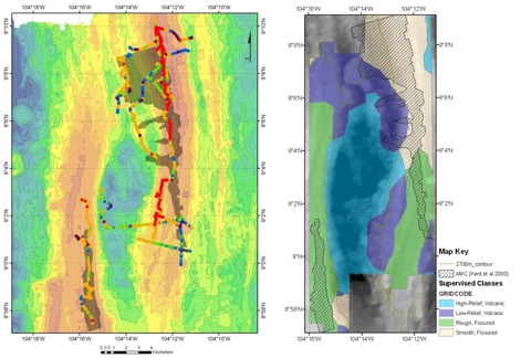
Figure 1. Left: Estimation of relative lava age (red = glassy, no sediment) based on Jason-2 and TowCam for 9°N OSC, with AMC outline from ARAD 3D seismic shown in dark shading over 20m, over bathymetry (20 m contour interval). Right: The four geomorphic provinces of the OSC determined by joint supervised-unsupervised classification of sidescan and bathymetry textures and named after their main geomorphic characteristic. The presence of a melt sill is not diagnostic of either recent eruptions nor untectonized terrain, although crystal content of the melt sill shows a better correlation with young-looking lava and smoother terrain. White_fig1.jpg