Weekly
Seismicity Along the Endeavour Segment from 2003-2006
R. Weekly¹*, W. Wilcock¹, E. Hooft², D. Toomey², & P. McGill³
Corresponding author: rtweekly@u.washington.edu
¹School of Oceanography, University of Washington, Seattle, WA 98195
²Department of Geological Sciences, University of Oregon, Eugene, OR 97403
³Monterey Bay Aquarium Research Institute, Monterey, CA
Abstract:
From 2003-2006, the W.M. Keck Foundation supported the operation of an ocean-bottom seismometer network along the Endeavour Segment of the Juan de Fuca ridge. The network comprised one broadband and seven short-period seismometers. Approximately 13,000 earthquakes were located for 2003-2004 by eight student analysts and ~6,400 earthquakes have also been located manually for a seismic swarm between late-February and early-March, 2005.
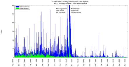
In order to obtain efficiently a complete catalog of earthquake locations for the full deployment period, we have developed an automatic location method to identify events, pick P- and S-wave arrivals, and locate earthquakes. We have automatically analyzed the entire deployment obtaining preliminary locations for ~38,000 earthquakes including ~6,600 earthquakes within the network. Our catalog confirms earlier results which show that a regional swarm centered approximately 10-15 km to the north of the network that began on February 27, 2005 triggered increased seismicity within the network with most of the local earthquakes between the Main and High-Rise fields. Additionally, we find that a smaller regional swarm beginning February 6, 2005, which occurred in a similar region, also triggered increased seismicity in the network but with most of the local earthquakes between the High Rise and Salty Dawg fields. These intriguing observations show that regional swarms that are close in both space and time can perturb seismicity associated with the Endeavour magmatic and hydrothermal systems in substantially different ways. Immediately following the swarms, seismicity rates markedly decrease to 20% of pre-swarm values and continue at low levels throughout the remainder of the deployment. We infer that the swarms substantially changed the regional tectonic stress field along the entire segment. Our data, combined with SOSUS records, lead us to postulate that the swarms mark the end of a 6-year non-eruptive spreading event that began in 1999.
Keywords:
Endeavour ISS, earthquake, spreading event
Contributions to Integration and Synthesis:
These results are relevant to the synthesis efforts of Ridge 2000 community members, because earthquake catalogs provide valuable spatial and temporal constraints on the deformation of oceanic crust, the emplacement of volcanic dykes, and the characteristics of hydrothermal circulation. Potential collaborative efforts include (1) integrating our dataset with existing SOSUS locations (Rob Dziak, Del Bohnenstiehl) for modeling earthquake occurrence rates based on the rate-and-state friction law. We are presently refining our preliminary locations and plan to release the catalog to the Ridge community within the calendar year, (2) correlating changes in seismicity to perturbations of hydrothermal temperature and vent-fluid composition (Marv Lilley, Dave Butterfield) as well as regional borehole pressure records (Earl Davis, Keir Becker), (3) investigating possible linkages between seismicity and a large increase in hydrothermal fluxes from the Salty Dawg field around July 2005 (Jon Kellogg). Relating the seismicity to models of the tectonic and magmatic evolution of the Endeavour segment is also of particular interest.
Along with our integration and synthesis efforts for the Endeavour ISS, our dataset provides an opportunity for comparative studies with the EPR ISS where an eruptive spreading event was recorded in 2005-2006 (Maya Tolstoy). Comparing patterns of focal mechanisms and spatial variations in b-values between the two study sites could resolve why extrusive volcanism was observed at one site, but not the other.
Figures:
Figure 1. Daily histogram of automatically located earthquakes during August 13, 2003 through October 14, 2006. Shaded bars indicate the number of events that locate within (green) or outside of (blue) the Keck seismometer network. Two regional swarms occurring in February and March 2005, triggered seismicity within the Main and High Rise, and High Rise and Salty Dawg vent fields, respectively. Weekly_fig1.jpg

