Carton
Characteristics of the crustal magma body in the 2005-06 eruption area at 9º50'N on the East Pacific Rise from a 3D multi-channel seismic investigation
H. Carton¹*, S. Carbotte¹, J. Mutter¹, J.P. Canales², M. Nedimovic¹’³, O. Aghaei³, M. Marjanovic¹, S. Han¹, M. Xu², & L. Stowe⁴
Corresponding author: hcarton@ldeo.columbia.edu
¹Lamont-Doherty Earth Observatory of Columbia University, Rt. 9W Palisades, NY 10964
²Woods Hole Oceanographic Institution, Woods Hole, MA
³Dalhousie University, Halifax, Canada
⁴Columbia College, Columbia University, New York, NY 10027
Abstract:
In the summer of 2008 a large 3D multi-channel seismic dataset (expedition MGL0812) was collected over the 9°50’N ISS at the East Pacific Rise, providing insight into the architecture of the magmatic system at the ISS and its relationship with hydrothermal activity and volcanic/ dyking events associated with the 2005-06 eruption.
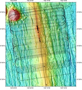
Most post-cruise efforts thus far have been targeted at defining strategies for data pre-processing (including a labor-intensive amplitude spike removal task and testing of filtering parameters), and defining the 3D bin grid geometry parameters that set up the environment for 3D processing. At this upcoming meeting we will present stacked/migrated sections obtained from the 3D binned 6-km streamer data within the main area of 3D coverage (between 9°42’N and 9°57’N; Figure 1). We will discuss results focusing on the characteristics of the AMC.
Keywords:
EPR 9°50’N ISS, seismic reflection imaging, crustal melt lens
Contributions to Integration and Synthesis:
Although in early stages of analysis this dataset has potential for integration with other data types at the ISS (microseismicity, high-resolution seafloor mapping, petrology/geochemistry of lava samples, geodetic observations) and models of hydrothermal circulation.
Figures:
Figure 1. Ship tracks of cruise MGL0812 in the 9°50’N area superimposed on multibeam bathymetry collected during the survey. Hydrothermal vents are indicated as black stars and the red contour marks the extent of the 2005-06 lava flow according to Soule et al. (2007). Carton_fig1.jpg

